Use APKPure App
Get NC Secondary Road LookUp NCDOT old version APK for Android
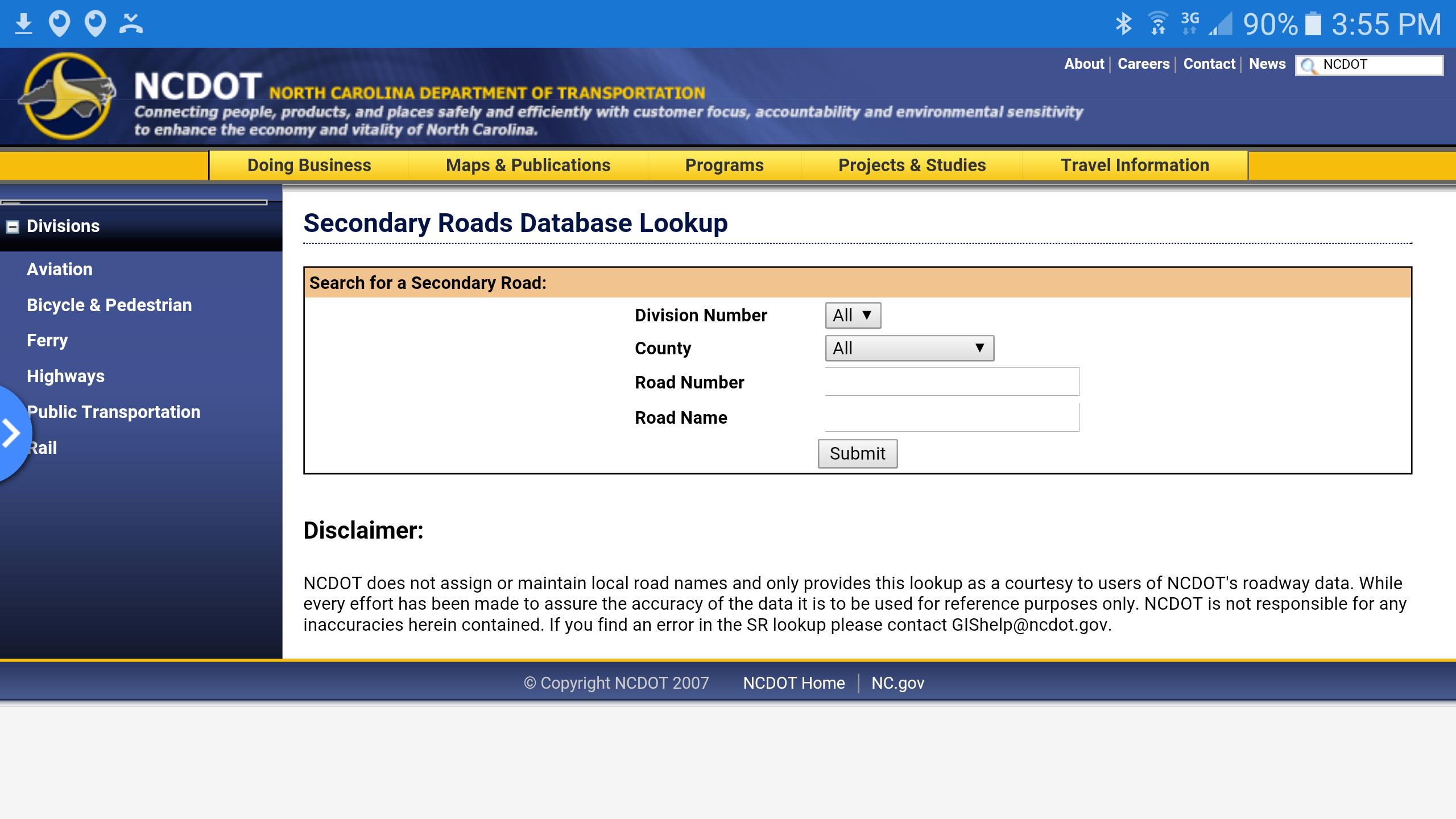
NC Secondary Rd Look-Up NCDOT par Realtor Michael Jones www.forsalegreensboro.com
Overview
The North Carolina Dept. of Transportation GIS Unit produces a substantial amount of GIS and imagery data and in many cases this data is available for download. The list of data below from NC DOT is not all-inclusive, but includes data that people often do not realize can be downloaded from DOT's website. Links and information content listed below are subject to change.
Core DOT Data
AlertNote:
If you need street centerlines (depicting streets, roads, highways, etc.) for just one or two counties, or a small area within one county, it will be easier to use data directly from the county using the links in the NC County Links Directory.
A statewide "mosaic" of all street centerlines (where possible - in some cases TIGER data is used) called the Integrated Statewide Road Network (ISRN) was compiled by the NC DOT in 2007. The centerlines were acquired from local governments, edgematched, and the attributes standardized. The data may be downloaded during non-business hours from the DOT Data page. Future updates are planned by DOT. NCSU affiliates may obtain a copy anytime from the Geodata Server by clicking here (113 MB). For more information, see this GIS News entry.
NC DOT Roads Data
State maintained road Arcs and Routes (shown at right) are available for download from the DOT Data page. These data do not include city streets, or road name attributes. Arcs are road segments split at each intersection. Routes are structured as the entire length of the highway.
Additionally, the following data produced by NC DOT are available for download:
NC County Boundaries
NC Municipal Boundaries (based on Powel Bill submissions)
NC DOT Administrative Division Boundaries
NC DOT Bridge Locations
NC DOT Bike Routes
Older copies of all these datasets are available. Contact Data Services for information.
Elevation, Hillside Shade, Slope, Sunshine Hours, Contours
Generated at the NCDOT GIS unit using NC LIDAR and USGS DEMs - Download Here by county. It is highly recommended to read the online documentation.
Also, see Elevation Data Sources for full discussion of data options.
County Digital Orthophoto Mosaics
MrSID mosaics created from the one meter 1993 black and white and 1998 Color Infrared statewide digital orthophoto quarter quadrangle (DOQQ) data are downloadable.
See the DOQQ webpage for more information about these products.
County Digital Raster Graphic Mosaics
Digital Raster Graphic (DRG) digital topographic map files are downloadable by Tile and by County. The original UTM, TIFF DRG data and the State Plane NAD 83 clipped (meters or feet) versions of this data are available as part of the Libraries geodata collection.
FEMA Q3 Flood Maps
FEMA's Q3 Flood Maps data may be downloaded from NC DOT. About one half of the state is available. See the FEMA Q3 page for important information about flood data for NC which is superseding Q3, access to the original Q3 data (NC, SC, and VA as part of the Libraries geodata collection) and Q3 data documentation.
Other Maps
Other map products produced by NC DOT's Information, Mapping, and Graphics Unit are available for viewing and/or download and include:
State Travel Map
County Maps
Bridge Maps
Bicycle Maps and Routes
Traffic Counts Survey Maps
Coastal Boating Guide
Primary Routes Map
Truck Network Map
Moving Ahead! Maps (land widths, crash factors, pavement conditions)
Crash Profile Maps
Reference Maps
Notes:
Older, georeferenced State Travel Map images are archived on the Libraries Geodata server in ftp://geodata.lib.ncsu.edu/stategov/dot/travelmap/. The 1997-98 collection includes individual maps for cities, also with world files.
1999 NCDOT traffic count data is archived on the Libraries Geodata server in shapefile format, State Plane NAD 83 feet or meters, at: ftp://geodata.lib.ncsu.edu/stategov/dot/traffic/. Brief documentation is available.
Last updated on Jan 7, 2017
Minor bug fixes and improvements. Install or update to the newest version to check it out!
Dernière version
![]() 2.0
2.0
Telechargé par
Christian Dale Lat
Nécessite Android
Android 2.3.2+
Catégories
Signaler


Discover what you want easier, faster and safer.

NC Secondary Road LookUp NCDOT
2.0 by Michael Jones RE/MAX Realtor in Greensboro
Jan 7, 2017