Use APKPure App
Get Portent old version APK for Android
Les données météorologiques pour les pilotes avec radar, satellite, METAR / TAF, plafond / vis et plus!
The Portent Aviation Weather app provides critical weather data you need to know before flying. METARs, TAFs, and satellite imagery are available worldwide. Winds, temperature, humidity, turbulence, and aircraft icing are shown at selectable flight altitudes across the US along with radar reflectivity, weather and precipitation types, and ceiling and visibility conditions. The Portent app retrieves and displays all of these current and forecast aviation weather conditions in a convenient and easy-to-interpret manner. The Portent app was developed by the original creators of the Aviation Digital Data Service (ADDS). It is fully functional during the 30-day trial period.
Map Features:
- METAR cloud and flight category icons and wind barbs (worldwide, latest surface observations)
- Radar base reflectivity mosaic (US, updated every 10 minutes)
- Satellite visible and infrared wavelengths (worldwide, updated every 30 minutes)
- Forecast radar, satellite, ceiling, visibility, flight category, weather, and precipitation (US, updated every hour out to 15 hours)
- 3D forecast winds, temperature, humidity, turbulence, icing probability and severity (US, selectable altitudes, updated every hour out to 15 hours)
- Basemaps with zoom-appropriate information like cities, roads, rivers, lakes, and airport runways (select "Simple," "Shaded Relief," or "Colored Terrain")
- Time-based animation
- Flight altitude selection for 3D products
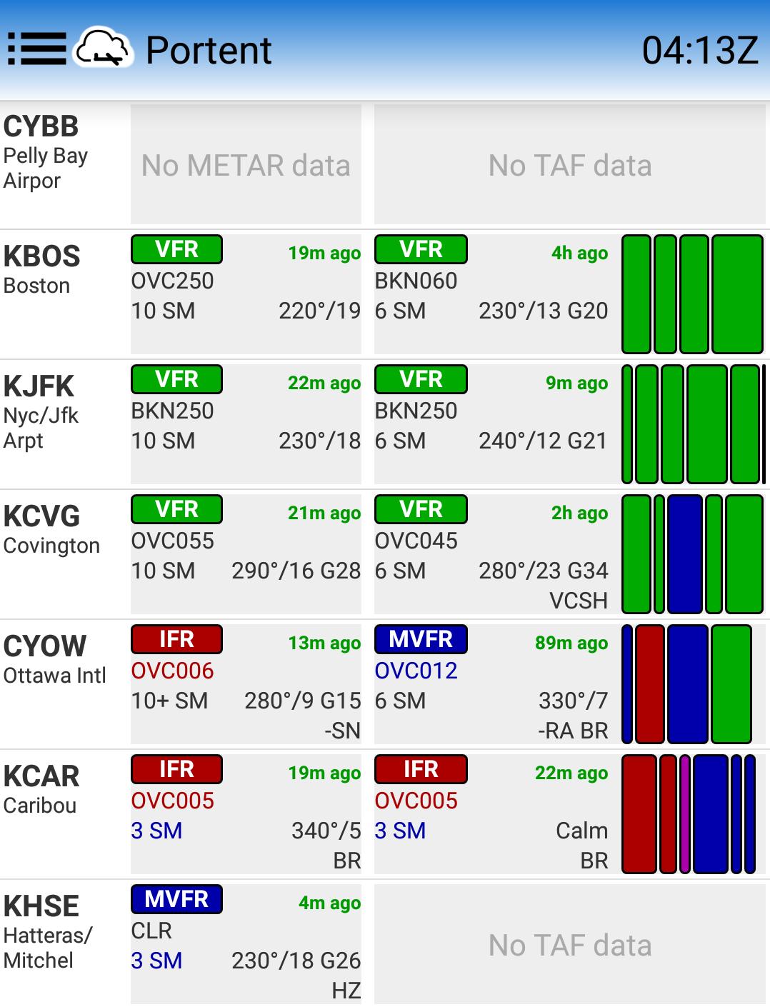
Station (METAR and TAF) Features:
- current (METAR) and forecast (TAF) weather conditions
- all sites worldwide
- at-a-glance primary flight conditions (VFR, MVFR, IFR, LIFR)
- user-customized lists of stations
- full text METAR/TAF available
- user-friendly display of clouds, visibility, winds, and weather
- the age of each report along with the current Zulu (UTC) time
Note:
- Some countries’ METAR and TAF reports may be formatted inconsistently compared to international standards. In those rare cases, reports may not be decoded and displayed as intended.
- Only U.S./English units are shown. A future release may support metric units.
Weather data are collected from reliable United States government sources, but we cannot guarantee that they will be available at all times. Portent Aviation Weather is for pre-flight purposes only and should not be used in flight. Worldwide, there are many sites that report current (METAR) data, but do not have official TAFs.
Last updated on Apr 6, 2018
Memory fix
Dernière version
![]() 3.0.20
3.0.20
Telechargé par
David EmmaNuel
Nécessite Android
Android 4.0+
Catégories
Signaler


Discover what you want easier, faster and safer.

Portent
Aviation Weather3.0.20 by Portent, LLC
Apr 6, 2018